Franklin Hill at one time had either a t-bar or a j-bar which ran up the farthest east portion of the slope, (right next to Franklin Rd), which was a ridge that faced north, west of Franklin Rd and south of 14 Mile Rd. There was a church that had a large parking lot on the north side at the base of the hill. There had also been at least a couple of rope tows too, on maybe 150 feet of vertical drop. Franklin Hill was already long-closed by the time that some friends and I wrecked a toboggan there in early 1976. About 6 or 7 of us had my folk’s toboggan and we were taking runs on Franklin Hill when we hit a jump that some kids had built and caught big air, followed by landing solid on the nose of the toboggan, breaking it clean off. A Franklin town cop came out and asked us if we were OK after we had been laying around in the snow groaning for a while. The memory makes me smile now.
To this day, we still ski train at Franklin Hill. That is dryland train.. I take my ski teams there a few days a week during the fall season, to prepare the kids for the coming winter. A great dryland workout hill. It is really steep, with an abrupt stop(flat) at the bottom.
Does anyone remember the old ski jump that was visible from Nine Mile Road in Farmington Hills? It went down the west slope of a ravine and made of wood. I last saw it in the 1970’s and it was old then. I would love to hear anything about it. Thank you.
Franklin tow ropes were removed in the early 1970s as a liability issue, altho kids still sled there. Located between the north edge of the cemetery and the softball field. Info from a nearby resident who also claims to have been one of the first owners, developers, and instructors of Mt brighton area
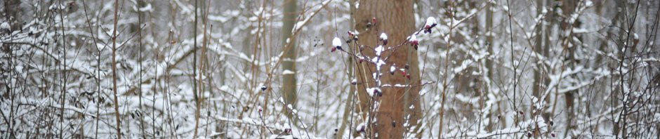
I got this shot of Franklin Hill from Carol Ave west of Franklin Rd. via Google Earth Streetview. I am afraid that the big tree in the middle of the shot blocks most of the view, however, either that little white building on the left or just beyond it was where there once was an overhead cable ski lift which could have been a pomalift, a t-bar, or a J-bar at one time. By the early 1970s all that remained were the steel lift towers and the overhead cable with the lower bullwheel still in-place.
To its right off in the trees you can still see one of the former ski runs, and behind the big tree is where the other run is. At one time there had been at-least one rope tow that had gone up the far west side of the hill too, but by the early 1970s the lifts had been closed for some time. The Franklin Church is to the right of the photo by just a couple hundred feet. The hill has become considerably more overgrown than I remember it but I haven’t seen it since I moved away from the area in 1982 either.
I used to work at the Franklin Standard gas station in 1975 (now BP) and graduated from high school in Bloomfield that same year. Maybe a half-mile north of Franklin Hill is the Franklin Cider Mill too.
This is a Google Earth satellite view of the former ski hill which is just south of the baseball field. I believe that the little cul-de-sac into the Franklin Cemetery wasn’t there when the ski hill was operating and the top of the hill may have been as high as Drummond Ct or even further.
One more Google Earth Streetview shot of Franklin Hill taken from Wellington Rd to the northwest of the Franklin Community Church across their athletic field shows the hill pretty well, though it is quite overgrown when compared to how it looked in the early and mid-1970s. In this view the overhead cable lift was to the far left side and the former rope tow to the far right side of the hill.

Franklin Hill at one time had either a t-bar or a j-bar which ran up the farthest east portion of the slope, (right next to Franklin Rd), which was a ridge that faced north, west of Franklin Rd and south of 14 Mile Rd. There was a church that had a large parking lot on the north side at the base of the hill. There had also been at least a couple of rope tows too, on maybe 150 feet of vertical drop. Franklin Hill was already long-closed by the time that some friends and I wrecked a toboggan there in early 1976. About 6 or 7 of us had my folk’s toboggan and we were taking runs on Franklin Hill when we hit a jump that some kids had built and caught big air, followed by landing solid on the nose of the toboggan, breaking it clean off. A Franklin town cop came out and asked us if we were OK after we had been laying around in the snow groaning for a while. The memory makes me smile now.
To this day, we still ski train at Franklin Hill. That is dryland train.. I take my ski teams there a few days a week during the fall season, to prepare the kids for the coming winter. A great dryland workout hill. It is really steep, with an abrupt stop(flat) at the bottom.
Does anyone remember the old ski jump that was visible from Nine Mile Road in Farmington Hills? It went down the west slope of a ravine and made of wood. I last saw it in the 1970’s and it was old then. I would love to hear anything about it. Thank you.
My mom and Dad told me it was built by a man who was in the Olympics back in the 1950’s. Don’t know his name
I believe I found a real estate ad for the house: http://www.cantonpl.org/sites/default/files/observer/1977/10_Oct%201977/10-03-1977.pdf.
Franklin tow ropes were removed in the early 1970s as a liability issue, altho kids still sled there. Located between the north edge of the cemetery and the softball field. Info from a nearby resident who also claims to have been one of the first owners, developers, and instructors of Mt brighton area
I got this shot of Franklin Hill from Carol Ave west of Franklin Rd. via Google Earth Streetview. I am afraid that the big tree in the middle of the shot blocks most of the view, however, either that little white building on the left or just beyond it was where there once was an overhead cable ski lift which could have been a pomalift, a t-bar, or a J-bar at one time. By the early 1970s all that remained were the steel lift towers and the overhead cable with the lower bullwheel still in-place.
To its right off in the trees you can still see one of the former ski runs, and behind the big tree is where the other run is. At one time there had been at-least one rope tow that had gone up the far west side of the hill too, but by the early 1970s the lifts had been closed for some time. The Franklin Church is to the right of the photo by just a couple hundred feet. The hill has become considerably more overgrown than I remember it but I haven’t seen it since I moved away from the area in 1982 either.
I used to work at the Franklin Standard gas station in 1975 (now BP) and graduated from high school in Bloomfield that same year. Maybe a half-mile north of Franklin Hill is the Franklin Cider Mill too.
https://www.google.com/maps/@42.5253869,-83.3070259,3a,15y,183.28h,90.61t/data=!3m6!1e1!3m4!1sFVVFx3v84fXUslOCB6k9jg!2e0!7i13312!8i6656!6m1!1e1
This is a Google Earth satellite view of the former ski hill which is just south of the baseball field. I believe that the little cul-de-sac into the Franklin Cemetery wasn’t there when the ski hill was operating and the top of the hill may have been as high as Drummond Ct or even further.
https://www.google.com/maps/place/Franklin,+MI/@42.5231299,-83.3075857,282m/data=!3m1!1e3!4m2!3m1!1s0x8824b9d0a0d7be45:0xb0cf685bd9b2c5c8!6m1!1e1
One more Google Earth Streetview shot of Franklin Hill taken from Wellington Rd to the northwest of the Franklin Community Church across their athletic field shows the hill pretty well, though it is quite overgrown when compared to how it looked in the early and mid-1970s. In this view the overhead cable lift was to the far left side and the former rope tow to the far right side of the hill.
https://www.google.com/maps/@42.5262052,-83.3085727,3a,15y,159.35h,89.98t/data=!3m6!1e1!3m4!1srMtlvrQNcNIO-_Yoz62eEw!2e0!7i13312!8i6656!6m1!1e1
Yes, barely. As a young child growing up in the 1970’s in Farmington I remember driving by an old dilapidated ski jump. It invoke both curiosity and fear to look at it.Watching this years Olympics brought back some memories. I called my Dad to see how accurate my recolections were. He said it was there all his life, was on Nine Mile Rd. on the east side of Farmington, maybe even in Southfield. It was privately owned and he never saw anyone using it. I found it was built before 1918 by Henry Hall a national and world champion ski jumper. Interesting guy. He continued jumping until age 79, then switched to cross-country skiing until he was 91.
Here’s some links with photos and details.
http://www.skihall.com/index.php?_a=document&doc_id=11&id=126
http://cdmbuntu.lib.utah.edu/cdm/singleitem/collection/UU_Photo_Archives/id/12355/rec/47
https://thelivingstonpost.com/taking-flight-on-flint-road-remembering-the-brighton-ski-jump/